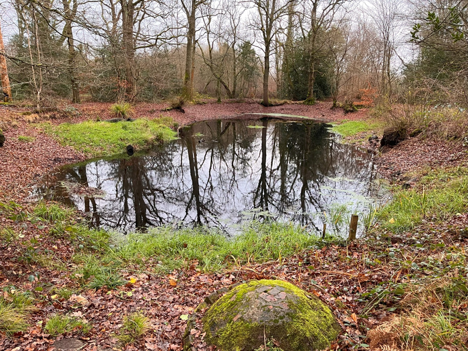
It was standing room only on 22nd January at the public meeting held by Woodcote Conservation Group (WCG) about the restoration of the Lower Greenmoor Pond.
Liam Woolley, WCG chair, opened the presentation by saying that the name Greenmoor is derived from Greenmere, Saxon for pond or pool. Written records from 1109 in the reign of King Henry I declare the ponds as being in the possession of Eynsham Abbey, but an expert from English Heritage told WCG in 2005 that the ponds could date from AD350 or earlier when they would have provided water for the occupants of a nearby Romano-British enclosure in Friarhampstead Wood. English Heritage also believed that the ponds may well have held some religious significance, due to their position at such a height in the Chilterns and so far from any running watercourse.
A resource essential for everyone, the Greenmoor Ponds are registered common land. The Upper Pond was used by livestock and the Lower Pond for domestic use. The ponds are shown on a map of 1818 and identified as a ‘public watering place’. A flight of 21 steps into the Lower Pond made it accessible during fluctuating water levels and the ‘dipping well’ was constructed in 1889 following advice from the Inspector of Nuisances of the Sanitary Committee of the Rural District Council in an attempt to filter water to make it more potable. This basic filtration system involves gravel at the bottom of a cylindrical brick structure into which buckets were lowered by hand. The Lower Pond continued to be an important water source for the community until mains water was installed in Woodcote in the mid-1920s.
Liam went on to explain that, as the Chiltern hills are a dry landscape, without springs or flowing water, the ponds have also been vitally important for wildlife for centuries. Every year toads, frogs, smooth newts and palmate newts migrate to the two Greenmoor Ponds and the large numbers involved make them an important breeding site. The ponds are a key resource for other species too. Last summer WCG carried out a series of bat monitoring sessions around the Greemoor Ponds which have built up a detailed picture of local bat activity. There are 17 species of bat in England, of which nine species were recorded – the common and soprano pipistrelle, natterer’s and Daubenton’s (myotis species), brown long eared, noctule, serotine, barbastelle and the rare nathusius pipistrelle.
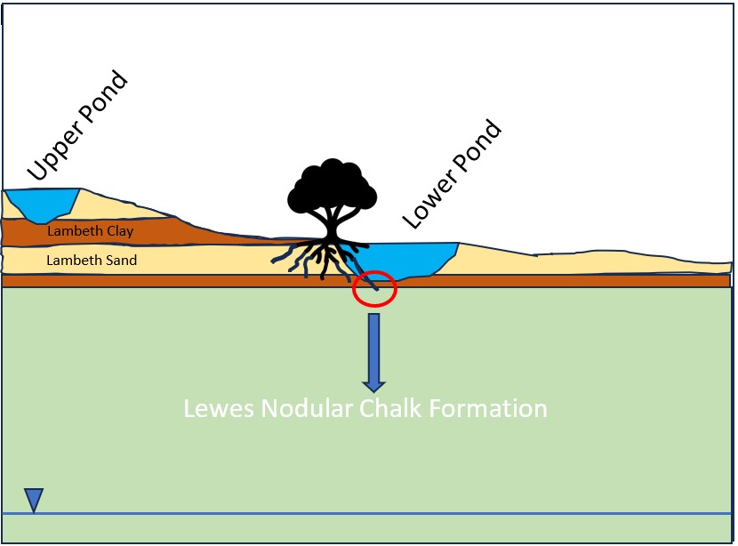
James Godfrey, a hydrogeological engineer and WCG member, then gave a fascinating insight into local geology explaining how the settlement of Woodcote only existed because the pockets of Lambeth Group clay and sands that locally cap the chalk in some areas of the Chiltern plateau. This shallow geology is important because it can yield and retain water at the surface, something that is necessary to maintain viable settlements before mains water was available. If you compare British Geological Survey maps and Ordnance Survey maps you will see this echoed across the Chilterns and Woodcote is a perfect example of this correlation. In the 1800s, with developing understanding of geology and the behaviour groundwater, some local communities dug deep wells into the chalk, eg the Maharajah’s Well in Checkendon where groundwater is 100m below the surface. Lambeth Group clays also provide valuable building materials allowing bricks and tiles to be manufactured locally, thus the local geology provides not only water storage, but also valuable materials for the construction of houses.
In just six weeks between May and June 2023, the Lower Pond lost all its water. Since December 2023 James has been monitoring the groundwater via a network of boreholes. The data indicate that the pond’s natural clay lining has likely been breached causing water that would normally accumulate in the shallow sand bands to drain through the confining basal clay layer into the underlying chalk. This water would ultimately find its way into the chalk groundwater table that is present some 120m below Woodcote. The wet weather caused the pond to partially re-charge over winter 2023/4 but the pond was completely dry again in July/August 2024. High rainfall since has caused the pond to partially re-charge again and, based on the considerable amount of data collected from the boreholes, James explained the groundwater outside the radius of influence of the damaged pond is healthy giving confidence that the Lower Pond will re-charge naturally if the breach is repaired.
He then went on to describe how the Lower Pond will be restored. The work will involve removing the silt which has accumulated over decades before new clay is brought in to re-line and seal the basal clay substrate, effectively re-sealing the base to reinstate the water-holding ability of the pond. The aim is to restore the Lower Greenmoor Pond to a condition that retains water through the seasons so that it can continue to form an important local aquatic habitat.
Four of the five contractors approached have provided quotes for the work, the cost of which is expected to be approx. £40,000. Woodcote Parish Council (WPC) has offered a contribution and, with support from WCG, has applied for a grant from the Trust for Oxfordshire’s Environment. This month WPC will learn if a grant has been awarded. Once the amount of the shortfall is known, WCG will crowdfund to raise additional funds. Kevin Davies, WPC Chair, concluded the subsequent discussion by saying the professional expertise brought to the project by members of WCG had been invaluable and the Parish Council fully supported the project to restore the Lower Pond, a precious community asset.
Ground Model – Schematic Cross Section