Woodcote: The Greenmoor Ponds
by Karen Woolley*
Historical background
The two ponds at Greenmoor, Woodcote (SU646812) cover an area of 1.635 acres [0.662 ha]. They are on registered common land and are situated at the second highest point of the South Oxfordshire Chilterns. The contrasting nature of the two ponds – the relatively shallow and very well vegetated Upper Pond and the much deeper, relatively sparsely vegetated Lower Pond, which is more heavily shaded by trees – adds to the value of the site both in terms of its visual appeal and ecological interest.
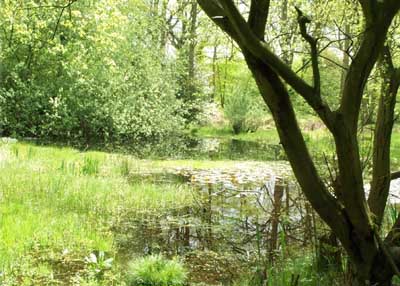
The Upper Pond
The name Greenmoor (also spelt Greenmore) is derived from Greenmere, meaning a green pond or pool, and is first mentioned in a document of 1109 when Henry I confirmed the possessions of Eynsham Abbey. The ponds are shown on a map of 1818 and were identified as public watering places in the Enclosure Award of 1853, and on an early (undated) map were named as ‘Sheep Wash Ponds’. The ponds were situated on the edge of Woodcote Common and people from outlying settlements would water their livestock at the ponds before entering the common through a gate at that end.
There is a mapped earthwork enclosure in nearby Friarhampstead Wood, less than 1 km away from the ponds. Representatives from English Heritage have recently visited this site and suggested that it may be Romano-British in date. As there are no other sources of water in the vicinity, it is considered that the Greenmoor Ponds may well have been used as a water source at that time.
The larger (lower) pond was still used as the main source of water for local people until the mid-1920s and the old well head can still be seen at the north-west end of the pond. English Heritage considers the Greenmoor Ponds to be of significant historical importance and accordingly has stated its intention to designate them a Scheduled Ancient Monument.

The Lower Pond circa 2000
Ecological background
Both the Parish Council and local people have always valued the Greenmoor Ponds for their wildlife, and in 1990 and 2000 Pond Action undertook a survey of the ponds and judged them to be ecologically important. The survey (undertaken by Jeremy Biggs of Pond Action) indicated that ‘both ponds have a very high conservation value’ and a rich fauna, including nine nationally scarce species. Some of the species recorded include water beetles, frogs, toads, and smooth, palmate and great crested newts (the latter were not recorded in the 2000 survey) and a wide range of plants. The site was considered to be within the top 15% of ponds identified by the National Pond Survey in terms of species richness.
As a result of the 2000 Woodcote Village Appraisal, the Woodcote Conservation Group (WCG) was established – mainly to manage the Greenmoor Ponds – and initiated discussions with Thames Water (which owns adjacent woodland) to manage the whole site as a wildlife area. The WCG (in association with the Parish Council) also commissioned a full ecological survey of the site and has since compiled a three-year management plan, to which it is now working.
Thames Water has not yet made a decision about the future of its area of woodland, but if it agrees to these proposals English Nature and Oxfordshire County Council have agreed that the whole site should be designated a Local Nature Reserve, due to its diversity of habitat. The Greenmoor Ponds are therefore not only of historical importance but also have considerable ecological importance.
Hydrology background
The hydrology of the Greenmoor site is not simple. The two ponds are physically close together but exist in a hydrological sense as two more or less separate entities. Any permanent changes in land use on site or within the catchment of either pond, or disturbances such as one-off excavation works or similar, could have an impact on water movements into, out of or through the site.
There have been no major changes in the condition of the Upper Pond (which has a separate and independent water catchment to the Lower Pond) but unfortunately from around 2000 to 2005 the level of water in the Lower Pond dropped steadily to a point were it was some two to three metres lower than its original level. There will always be seasonal cyclic changes caused by variations in precipitation, with lower water levels to be expected after dry summers or winters, but the dramatic drop in level of the Lower Pond could not be the result of any such seasonal changes.
The Lower Pond receives water from several sources. There is a series of springs at the western end of the pond, which were possibly the source of water for the well (now capped). The pond also receives direct precipitation and some run-off from the surrounding land, although this is limited because the catchment area is small. Evidence also suggests that there is sub-surface flow into the eastern end of the pond from the north. This flow enters the pond by seepage through either the upper part of the bank and/or at a lower level. The precise route of this water is not known. While these sources continued undiminished the pond remained full, with only a relatively small drop in water level during the summer months. However, the loss or reduction of one or more of these sources would probably cause the water level to drop. Damage to the pond lining could also cause the level to drop, if the rate of water flow into the pond were not sufficient to compensate for the rate of out flow.
The start of the drop in water level coincided with ground works close to the pond to bury electricity cables formerly located above and along the length of the pond, but this work was eliminated as the cause of any alteration to water flow into the pond, by careful excavation around the cables indicated that the surrounding area was completely dry down to a level of approximately two metres.
Having eliminated one possible cause for the drop in the level of the pond an initiative was instigated by WCG to find the cause and rectify it. This was the start of what would turn out to be a extensive project running of a number years to carry out restoration of both the lower and upper ponds. (See Projects Section)
Lower Pond: Update, September 2006
Below is a message from the WCG to the community in 2006, which adds to the historical perspective of the ponds
Yes, it does look a mess! (And things have not been helped by the vandal(s) who so badly damaged two of the adjacent oak trees that they had to be felled for safety reasons.)
For the past 6 years, the level of water in the lower pond has been steadily dropping. The Woodcote Conservation Group – with support from the Parish Council – has been managing a project to find out just what has caused this dramatic change in water levels.
Over the past 18 months we have been working with the UK’s leading pond experts, the charity Pond Conservation (www.pondstrust.org.uk), who have provided funding for a Hydrologist to carry out a detailed survey of the site.
Information gathered from over 20 bore-holes in the surrounding woodland, along with regular monitoring of local rainfall, has shown that the underground aquifer – the main source of water to both ponds – has somehow been diverted and has ceased to flow towards the lower pond. This has meant that without this underground ‘spring’, the pond has only been fed by rainwater, and has thus gradually reduced to the level you see today.
One positive aspect of this reduction in water level is that a set of steps adjacent to the old ‘well-head’ has been exposed, having been hidden from view for the past 80 years. An expert from Oxfordshire Archaeology believes that these steps would have been used to access the water for cooking and washing purposes, before the well was finally capped off in the late 1920s.
Now the problem with the pond has been identified, we have to do something about it. Unfortunately, this is an expensive exercise! It has taken over a year to access the funds needed to pay a professional contractor to carry out the work to ‘by-pass’ the underground breach in the water course and to re-direct the water towards the pond.
We will also be re-structuring the banks of the pond to reduce some of the steep sides and create a pond which has greater wildlife value. This work will begin in Autumn 2006.